Section 3: Tonopah Cache to Eureka
(approx. 190m)

(section elevation: 37,250ft gain, 36,875ft loss)
Section 3, Segment I: Toiyabe Crest
Highway 376 at Tonopah Cache to Highway 376 at Big Smoky Valley Cache
(approx. 50m)
Section 3, Segment I: Toiyabe Crest
Highway 376 at Tonopah Cache to Highway 376 at Big Smoky Valley Cache
(approx. 50m)
(22m road, 23m trail, 5m XC)
(mileage estimation with XC factor: 51m)
(approx. 10,000ft elevation gain, 10,450ft elevation loss)

 The Toiyabe Crest is arguably one of the top highlights of the Great Basin Trail. The Toiyabe Range is 120m long and one of the largest and longest mountain ranges in the state. The high point is Arc Dome at 11,788ft and the GBT passes just below the peak. A GBT hiker can easily attain Arc Dome via the saddle about a mile north of the peak on a steep climber's trail. The range is managed by the USFS and has a great trail network that is highlighted by the Toiyabe Crest Trail which runs 72m across the crest of the range from Twin River Road to Kingston Creek Road. I chose the GBT to utilize the TCT because of the sheer beauty of the range and the high crest trail. But, I chose to utilize 20 or so miles of the TCT for the GBT because of the effort to get east and to massively swing back towards the Alta Toquima. In some instances, because of the remoteness of the GBT, I felt the need to keep sections achievable for hikers. Another advantage too for the departure of the TCT at Ophir Summit is that at Highway 374, where Ophir Road terminates in the Big Smoky Valley, the GBT is within 10m of the small town of Carvers, which has all, although minimum, amenities.
Of the 50 section miles, 22 miles are on dirt road, 23 miles are on very good trail tread, and in the beginning of this section the hiker cross-countries some easy miles across the Big Smoky Valley. This section in the springtime can have lingering snowfields and cornices. Inclement weather can pose a hazard to hikers because of the high elevation hiking above timberline. Cache points are at the beginning and ending of this section.


Section 3, Segment J: Alta Toquima
Highway 376 at Big Smoky Valley to Monitor Valley
(approx. 40m)
(16m road, 15m trail, 9m XC)
(mileage estimation with XC factor: 42m)
(approx. 8,050ft elevation gain, 6,825ft elevation loss)
 The Toquima Range is very tall in stature, abruptly tall. The range is characterized by a very large plateau of subalpine tundra on the 3 summits of Mt. Jefferson. This is spotlight of the Alta Toquima Wilderness which culminates at the southern high point of Mt. Jefferson at 11,949. This is also one of the Great Basin Trail's highest points. Views from the summit are absolutely spectacular as one can see all the way to the Palisade Glacier area of the Sierra Nevada. The views are so vast that one can see the high point of Death Valley NP at Telescope Peak to the south and the high peaks of the Ruby Range to the north. These distances span an incredible distance as compared to other vistas in the Great Basin. In the lead up to the Alta Toquima, one crosses the wide Big Smoky Valley and contours steeply up through the mesas that lead up to the Alta Toquima. Once atop the high alpine plateau a trail plummets down Andrews Basin and the hiker ends up in the rugged and choked Trail Canyon. Trail Canyon starts off as easy cross country, but once the canyon squeezes the hiker is then thrashing the way down the rest of the canyon to the alluvial fans above the Monitor Valley.
The cross country parts in this section are minimal and relatively straightforward. The road walking is pretty easy, well, covering 16 miles of the sections estimated 40 or so miles. The toughest challenge in this section mileage is the trail miles, some 15 miles worth. Some tread is fairly good, while some of the tread is non-existent. Most maps show a Trail in Trail Canyon, but one is hardly existing. One can expect swift travel in the lower parts, while in the higher reaches and the canyons the hiker can expect to really slow their miles per hour down.
 The extreme exposure in the Alta Toquima is clearly palpable, not only in the vistas and the high plateaus, but on your skin. You are either hot or cold, wind-thrashed or cold-bit, tramping on good trail or bushwhacking through a tangled mess. The rewards are very fulfilling once through the traverse of the Alta Toquima. You feel accomplished yet lucky in being able to get through unscathed, although your scratched shins and sunburnt cheeks and nose may say differently. For us, we experienced extreme cold and camped on crusty snow at around 9,800ft. We set up our tarps close together and as a windbreak for the fire we started. We gathered firewood for the night to keep us warm, as we expected temperatures to drop between 15-20 degrees. As the sun sank, a pink glow shimmered in the Moore Creek Basin and we felt toasty sitting on a rock near the fire. In the freezing morning, we broke camp quickly and began the slow plod up to the large plateau of Mt. Jefferson. Once atop the plateau, we observed the panorama of many mountain ranges. The Toquima Range continued in a crooked northern line that felt to be a molded topography of a different range because of how high we were. We hiked atop crusty snow and the sun's refulgence warmed us up. We summited the high point of the broad peak and soaked up the views.
  Then, we picked our way through the talus fields to Andrews Basin and followed the ribbon of snowmelt roaring in the small creek. I had been waiting for Trail Canyon since I had scoped the route out in 2015. I wanted to efficiently get through without suffering because of how constricted and choked the canyon got. After a lunch in a shady alcove, I felt ready to tackle the obstacle. We meandered down the curves of the canyon, as the tall and chunky cliffs loomed above us. We even found a bighorn sheep skeleton with the skull still attached to the spine. Some mummified fur still clung to the facial curves of the skull and looked eerily gaunt and alive. As soon as we came to the choke point, my memory became flooded of my past experience bushwhacking through here. We strove on and I picked the way efficiently and climbed up a gully, over an overlook of the u-bend, and skidded down another talus-filled gully. As the canyon widened, juniper and pinyon became more present and I could see the Monitor Range across the basin. Trail Canyon wasn't as bad as I thought.


Section 3, Segment K: The Monitors
Monitor Valley to Sevenmile Wash
(approx. 52m)
(23m road, 19m trail, 10m XC)
(estimated mileage with XC factor: 55m)
(approx. 10,650ft elevation gain, 9,800ft elevation loss)
 The Monitor Range finishes off the rugged succession of the Toiyabe-Toquima-Monitor trio which presents brutal elevation loss and gain, extreme climate and exposure, and incredible remoteness. These central Nevada ranges form a curve within the Great Basin Trail's loop. To complete the route in full one will exert a ton of effort. Caching food, timing the weather, and snow conditions need to be considered. The hiker needs a bit of luck too on top of the preparedness. Both the Toquima and the Monitors are in the rain shadow of the Toiyabe. So, if the Toiyabe receives a snow dumpage the Toquima will receive snow because of the range's high elevation, but will have slightly less, while the Monitors will hardly get any precipitation. That being said all 3 ranges are cold and windy, although incredibly beautiful. The Monitors are the easiest to travel in of the 3 ranges although one may be more exposed along the lengthy crest of the Monitors.
 The Monitor Range finishes off the rugged succession of the Toiyabe-Toquima-Monitor trio which presents brutal elevation loss and gain, extreme climate and exposure, and incredible remoteness. These central Nevada ranges form a curve within the Great Basin Trail's loop. To complete the route in full one will exert a ton of effort. Caching food, timing the weather, and snow conditions need to be considered. The hiker needs a bit of luck too on top of the preparedness. Both the Toquima and the Monitors are in the rain shadow of the Toiyabe. So, if the Toiyabe receives a snow dumpage the Toquima will receive snow because of the range's high elevation, but will have slightly less, while the Monitors will hardly get any precipitation. That being said all 3 ranges are cold and windy, although incredibly beautiful. The Monitors are the easiest to travel in of the 3 ranges although one may be more exposed along the lengthy crest of the Monitors.
 Of the section's 52m, 23 miles are on remote and rugged jeep track or what some would consider two track. The 19 or so miles of trail in this section are documented on maps, however once in the alpine area of Danville Mountain the trail becomes very faint. Even so, the walking is easy through here despite the elevation loss and gain. Lastly, the cross-country mileage in this section are rough. Some parts utilize well-trampled horse and elk trails, while other parts can be thick with mahogany. A useful hint through here besides taking the time to find the horse trails, but to seek out the open slopes of sagebrush rather than the thicker slopes and hill tops of mahogany.
 The Monitors are incredibly linear and the heart of the range lies in the Table Mountain Wilderness. High plateaus resemble a large table where you trod on alpine grass. The wind shapes the trees out on the high plateau and although the tableland is 1,000ft lower than the Alta Toquima the area presents the same starkness and aridity. That being said, a couple large creeks flow from the plateaus. The forested environs are a noticeable change as compared to the other 2 previous ranges. The hiker also feels the more northerly push of the Great Basin Trail. Wildlife is abound in this range, in particular large herds of elk. Hunting camps reside creekside along Barley Creek and the hiker begins to see the etchings of a sheepherder's past on the aspen. Once the experiencer travels through the high plateaus, the crest becomes narrower and lower yet one feels farther 'out there.'
 The Monitors are incredibly linear and the heart of the range lies in the Table Mountain Wilderness. High plateaus resemble a large table where you trod on alpine grass. The wind shapes the trees out on the high plateau and although the tableland is 1,000ft lower than the Alta Toquima the area presents the same starkness and aridity. That being said, a couple large creeks flow from the plateaus. The forested environs are a noticeable change as compared to the other 2 previous ranges. The hiker also feels the more northerly push of the Great Basin Trail. Wildlife is abound in this range, in particular large herds of elk. Hunting camps reside creekside along Barley Creek and the hiker begins to see the etchings of a sheepherder's past on the aspen. Once the experiencer travels through the high plateaus, the crest becomes narrower and lower yet one feels farther 'out there.'
We scampered atop the plateau with ease despite the bone-chilling wind. Small alpine flowers braved the elevation and exposure to flourish closely to the ground. A brief encounter with these little flowers only blinded me from the stinging cold and the notion of an impending storm and cold front. We hunkered on the leeward side of the range that abruptly fell off down the cliffs of the eastern side. We rested our feet atop a cornice leftover and wind blown from a Winter's havoc. Then, a few hours later, we scoped out the route along the crest as the clouds slammed into the tops and then dissipated into the emptiness of the drainages to the east. No trail existed and we picked our way between mahogany and pinyon. I turned to Pep and shouted: We are being 'mahoganied!' ----the phrase I created for the unworthy way across the 8,000-9,000ft level where if you hit a forest of mahogany the hiker became entangled in a leafy snare that would catch and grab the hiker's clothing and shred the skin of the shins and forearms.
 We pushed on vetting a route that I believe is probably not too enjoyable for the GBT. Later on I scoped out another way around the 5 mile stretch, which took us 3 hours to do 4 miles within the snare. On the way around, we travelled down a creek on elk paths to attempt the snarled traverse. We should have kept down the creek and wrap around the unpleasing way to Dobbins Summit. From Dobbins we would then follow what Pep had mapped out, which looks very doable from satellite imaging and from one's view from the basin floor. I don't think we stopped up on the crest as the cold weather pushed into us. We sat under a juniper below the crest to decide our way next. We chose the way down Dobbins Summit to the Little Fish Lake Valley. We walked on shivering and found camp in the pinyon flats feeling fortunate to be out of the brittle wind.
Update: In my spring 2021 hike, I vetted the route Pepperflake had drew from the previous year. It goes and it is incredibly scenic with a couple new water sources. The newer map set and Gaia track set will have this new information. On my hike through Butler Basin, I ran into probably a 100 head of wild horse and a couple bull elks with some rather large racks.


The cruiser ridge line stemming from the high plateau of the range to Ninemile Peak is windswept and rocky. Elk roam the high parts and as I rambled through here I ran into a couple bull elk laden with enormous antlers. The final push up to Ninemile Peak is among a loose talus field which tops out at over 10,000ft. The surrounding views are breathtaking and the feeling of emptiness is profound. That being said, I summited the peak on the same day another fellow had done so. Through the small summit register I saw that over the years only a couple hikers visit the the lonesome peak annually. So, having two peakbaggers unknowingly top the peak in one day seemed like such a rare feat. Out here on the Great Basin Trail, there is a semblance of randomness that is more perceptible than in crowded areas. Maybe the feeling of randomness is heightened because of the isolation. I am not entirely sure, but it is there. It is the mystery of a vast landscape where you recall what draw you were in in a snowstorm or what basin during a windstorm, or you can observe from a distance a storm system move hundreds of miles across the landscape and you just instinctively know where that storm system is going to. Without a tremendous feeling of civilization surrounding you the world feels closer, feels more connected. Almost like tied to spirits of the past, some hidden wavelengths parallel from our reality aside a mirage or a dreamscape. From Ninemile Peak, the heat waves of the basins below shimmer and the clouds push through the sky at a ferocity spurred on by the wind. Far down below a wisp of dust tails a car speeding along a dirt road. I know a connection exists and I long for a random conversation where we can search out the meaning of it all, of whatever the meaning of it all feels like in an immense abyss like the Great Basin.


Section 3, Segment L: Antelope and Fish Creek Ranges
Sevenmile Wash to Eureka
(approx. 47m)
(31m road, 16m XC)
(mileage estimation with XC factor: 52m)
(approx. 8,550ft elevation gain, 9,800ft elevation loss)

The Antelope Range is an overlooked range in a very remote area. While you are more likely to encounter ranch hands and hunters in the rugged jeep track meandering through the lower parts of the range, Ninemile Peak remains lonesome and solitary. The primitive area surrounding the peak is now a Wilderness Study Area. Most visitors to this isolated area frequent the more popular ranges of the Toiyabe and the Toquima, as well as the many hot springs in the area. So, if seeking solitude in a section of the Great Basin Trail, the Antelope Range fits the bill. In the northern part of this section, just south of Eureka, the GBT rolls through the Fish Creek Range's foothills before tackling the high summits of White Mountain and Prospect Peak. Up here, one can find bristlecone pines among the gnarled limber pines that dominate the higher elevations in this area.

This section is remote and rugged. Of the 47 estimated miles, 31 or so miles are on rugged jeep and two track. In some cases, the way through are old mining roads where one only traces a corridor. For the 16 or so cross-country miles, one can expect the mileage to be greater due to the rugged manner of the terrain. In some instances, wild horse trails are followed, while south of Ninemile Peak is rocky and sometimes slow going.


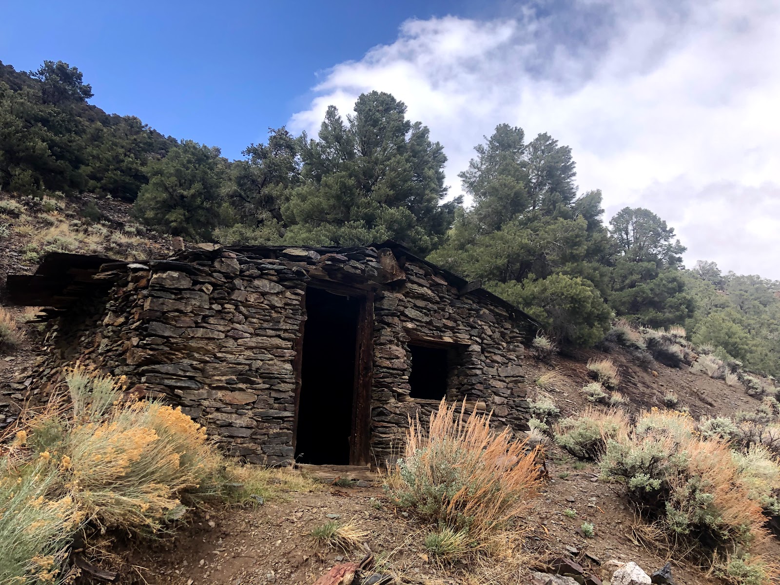
The segment explores the Fish Creek Range, as well. Wild horse rove the lower parts among forests of pinyon and juniper. Basically, disappeared mining track weaves along the foothills ducking in and out of drainages. After an easy traverse, the route encounters McCulloughs Butte, which one finds the boom and bust past of gold and silver mining. Old track switchbacks and explores the hillsides, rusty pieces of metal strew the area, and wild horses take advantage of the isolation here to have established a new territory. I clambered my way up the weaving old mining roads before wrestling briefly with a mahogany thicket. Once atop the range on Prospect Peak, the aerial towers of the flat tops finally gave me an unwelcomed hope of a sight of civilization. From Prospect Peak, I could see even more scarring from mining, more adits and more dirt roads. Most importantly, I could see from my perch the small town of Eureka, the first town since Pioche some previous 400 miles, that I would actually walk through. I had gotten used to not being around people for so long the sights of the massive structure appeared so foreign to me and not like the basin and ranges I had become so accustomed to. I started to think how I would interact with people and if I would I have the same voice and tone like I had had with the wild horses which had been my main companions thus far.


No comments:
Post a Comment